Improving Agricultural Efficiency with Satellite Data
- by 7wData
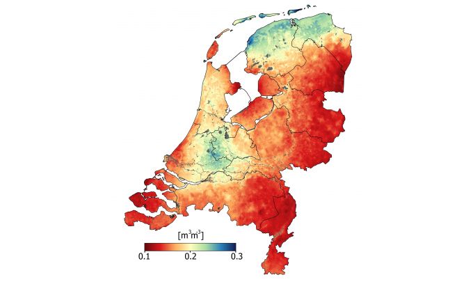
Humans started to cultivate land around 10 000 years ago, so we must be pretty good at it by now. However, environmental concerns, sustainability, quotas, subsidies and paperwork make farming more challenging than ever. Satellites offer a solution to many of these problems, but how does the ordinary farmer tap into their potential? Satellites such as Europe’s Copernicus Sentinel missions and ESA’s SMOS and the upcoming Florescence Explorer, FLEX, provide a wealth of information about growing conditions and crop health that can be used to improve agricultural efficiency.
But Satellite data are just the starting point – they have to be turned into easy-to-use applications to be of any real value to farmers. Ger Nieuwpoort, director of the Netherlands Space Office, said there is clearly huge potential for Earth observation to be exploited much more than it is today. For example, we see a gap between organisations that develop extremely sophisticated satellites and people in the field dealing with farming subsidies. Ironically, in the world of agriculture, the gap between raw data and possible end users is a largely ‘uncultivated’ area, Nieuwpoort added.
Despite it being a small country, the Netherlands is one of the world’s largest exporters of agricultural and food products, and a country that adopts ever-increasingly sophisticated techniques to keep the Business efficient and sustainable. A recent workshop at the Netherlands Space Office attracted representatives from the farming community, consultants, companies that turn data into usable products, and scientists.
Maurice Borgeaud, head of ESA’s Earth Observation science, Applications and Climate Department, said the workshop attracted such a wide range of actors, highlighting that Earth observation data are not only used for science and to develop applications, but also for the commercial downstream market, and hence play an increasingly important role in business and the economy.
The Sentinel missions are revolutionising the way Satellite data are used for practical purposes such as farming.
[Social9_Share class=”s9-widget-wrapper”]
Upcoming Events
From Text to Value: Pairing Text Analytics and Generative AI
21 May 2024
5 PM CET – 6 PM CET
Read MoreCategories
You Might Be Interested In
How AI is winning the war against fake news
14 Jun, 2017In 2014, the term “fake news” hadn’t yet become part of the American lexicon and the 2016 U.S. presidential race …
What does a data science team look like?
26 Nov, 2019Until a couple of years ago, people barely knew the term ‘ data science’ which has now evolved into an …
How to Avoid the Data Silo Trap
30 Jan, 2022The key goal of a data-centered architecture is data accessibility. Accessibility can impact future business innovation, improve the ability to …
Recent Jobs

Do You Want to Share Your Story?
Bring your insights on Data, Visualization, Innovation or Business Agility to our community. Let them learn from your experience.
Privacy Overview
Get the 3 STEPS
To Drive Analytics Adoption
And manage change